
NUSO 2014 Research Missions
Stream Temperature Dynamics Study
Tribal Youth Program in Klamath Basin, Oregon
The Klamath Basin comprises over 40,000 square kilometers and encompasses a diversity of habitats and trust species including threatened and endangered species, migratory birds, and anadromous fishes. Aquatic habitats supporting trust species such as Lost River sucker, shortnose sucker, and Coho salmon in the Klamath Basin are supported by an array of aquatic, physical, and habitat conditions.
Degradation of habitat by diminished stream flow, altered thermal regimes, and stream bed and bank modification are key factors influencing populations of many aquatic trust species in the Basin. As an example, the once abundant Klamath salmon runs have been reduced to less than 10% of their historic size. Some species, such as Coho salmon, are now in such low numbers in the Klamath River that they are listed under the Federal Endangered Species Act (ESA).
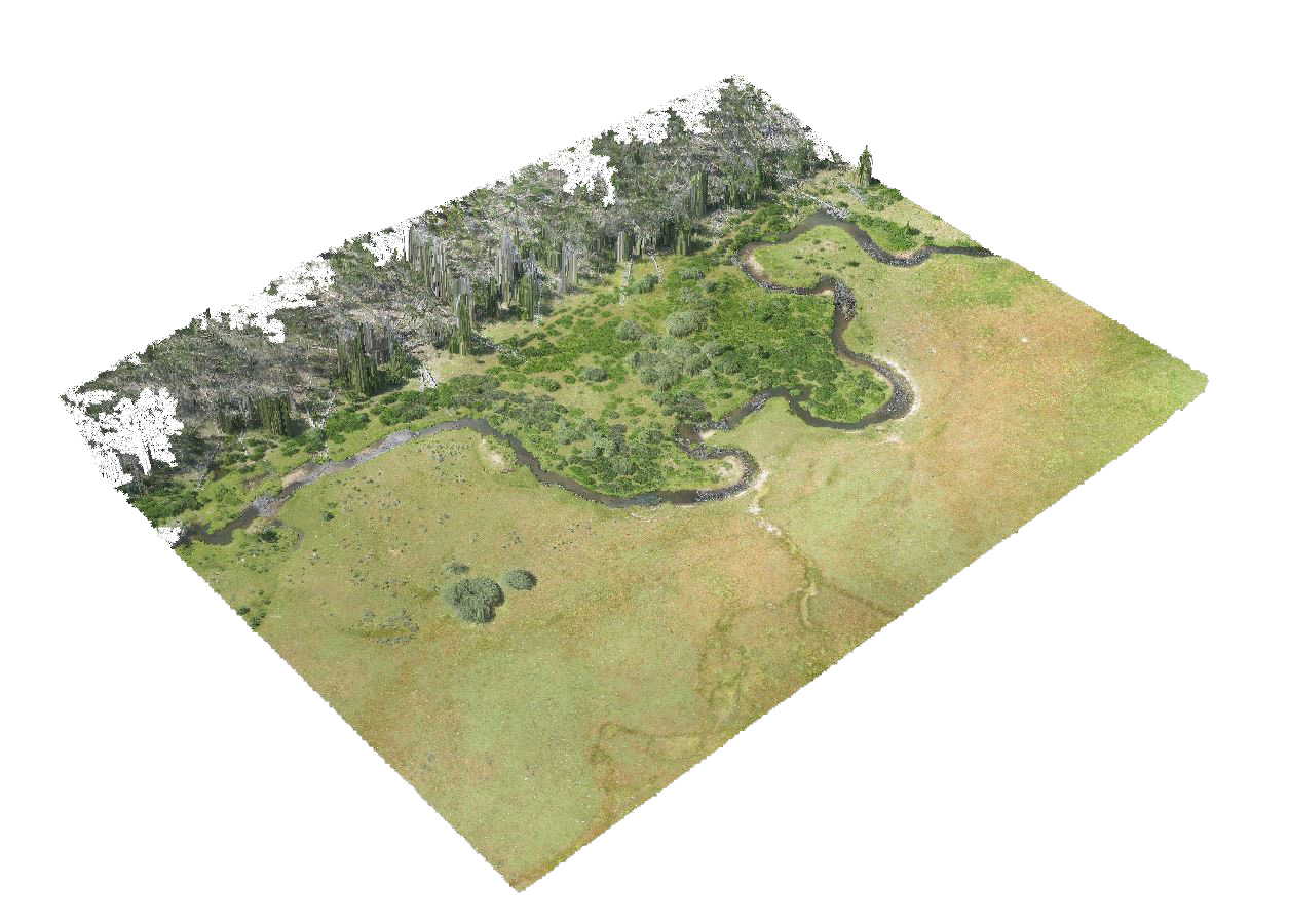
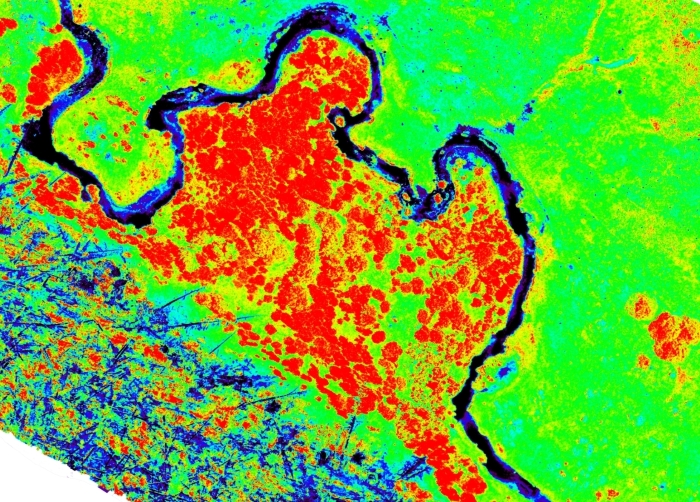
The USGS-FWS-Klamath Basin Tribal Youth Program is studying stream temperature dynamics on the river systems within the Upper Klamath Basin. This project will investigate the utility of thermal infrared (TIR) remote sensing on UAV-platforms to measure stream temperature by studying instream observations, mapping the images with historical geomorphological data from satellite imagers, and validating the results with on-the-ground point measurements and historical data, such as LiDAR and Forward Looking Infrared (FLIR) from 1999 and 2012.
Data collections will be timed to capture daily maximum stream temperatures. In-stream temperature data loggers will be used simultaneously with the over flights to ground-reference the radiant temperatures measured by TIR. The project will collect data for analysis to assess utility in the development of workable and locally accepted stream temperature best management practices for the Klamath River Basin and its tributaries.
This program received the Partners in Conservation Award 2013 by the Department of the Interior for outstanding contributions of the Klamath Tribal Leadership Development Program for Integrative Science & Traditional Ecological Knowledge. (see citation link below).
Study Point of Contact:
Sue Mattenberger, Hydrologist
U.S. Fish and Wildlife Service
sue_mattenberger@fws.gov
Publication:
2013 Partners in Conservation Award 
Census of Ground-nesting Pelicans
Chase Lake National Wildlife Refuge in North Dakota
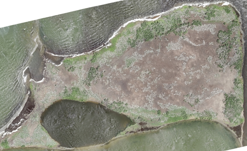
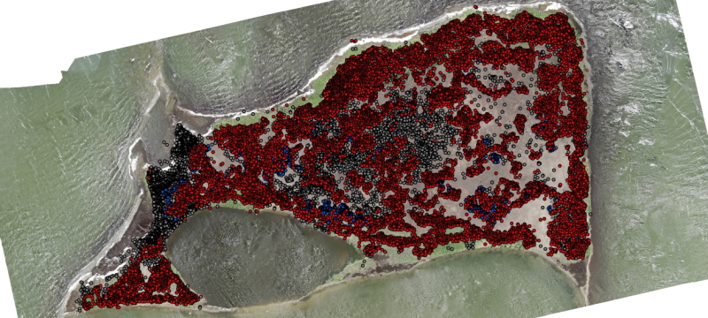
Chase Lake National Wildlife Refuge (NWR) in south-central North Dakota is home to one of the largest colonies of ground-nesting waterbirds in the northern Great Plains. The waterbird colony at Chase Lake NWR has changed dramatically during the past two decades, increasing both in species composition and in overall numbers. In recent years, the Chase Lake islands supported 20,000-30,000 nests of 40,000-60,000 breeding birds (12+ species), making this one of the most significant mixed-species waterbird colonies in the northern plains and certainly one of the most important colonies managed by the U.S. Fish & Wildlife Service (USFWS) in this region. Such a large concentration makes the breeding birds especially vulnerable to multiple factors (e.g., predation, weather events, disease) that can influence their productivity and survival. Access to reliable population data is crucial for effective conservation and management of the Chase Lake waterbird colony and other colonies in the region.
Ground surveys by walking observers were used at Chase Lake NWR in the 1970s when the waterbird colony was much smaller. Ground surveys are not recommended because this technique is known to cause disturbance and nest abandonment of American White Pelicans and other waterbirds. Annual aerial surveys of nesting pelicans using manned fixed-wing aircraft (e.g., Cessna 172) have proven critical in documenting the increases and decreases in American White Pelican populations at Chase Lake and other regional pelican colonies in recent years. However, aerial surveys using manned aircrafts have potential complications, including safety, costs, and logistics. For example, the ideal timing (i.e., late May or early June) of the aerial imagery from manned aircraft often conflicts with other refuge priorities (e.g., easement assessments, law enforcement, etc.) and schedules for USFWS pilots. For safety, pilots often avoid low-altitude flights. The resolution of the photography from manned aircrafts often is insufficient to identify individuals of smaller waterbird species such as gulls. The aerial surveys using fixed wing aircraft did not utilize remote sensing with high resolution color or infrared imagery, which would allow better detection of individual birds on nests.
Monitoring of waterbirds is essential to detect and evaluate changes in waterbird distribution and abundance. At present, there is some urgency to continue to develop reliable methods for estimating population sizes of ground-nesting waterbirds at Chase Lake NWR. Reliable baseline information on breeding population sizes and changes over time would allow the USFWS to evaluate population levels and changes and to make informed decisions. Unmanned aircraft systems (UAS) are proving to be a useful alternative to manned aircrafts for wildlife surveys and have the potential to be more economical, less obtrusive, safer, and a more efficient and versatile means to survey nesting pelicans and other ground-nesting waterbirds. High-resolution color images and infrared images will provide detection of individual nesting pelicans and other ground-nesting waterbirds.
Study Point of Contact:
Ned Wright, Habitat and Population Evaluation Team (HAPET)
U.S. Fish and Wildlife Service
ned_wright@fws.gov