
NUSO 2018 Research Missions
Archeological Site Management
Petrified Forest National Park in Arizona
The Petrified Forest National Park, located in northeastern Arizona, contains over 600 archeological sites distributed over the 230 square miles that must be monitored and preserved by the National Park Service (NPS). Because of the vast size of the park combined with the significant number of archeological sites the NPS determined that access to high resolution data is crucial to support their efforts to document archeological sites, help assess damage to the sites, and identify newly uncovered sites in both the core of the park and within areas of the boundary expansion.
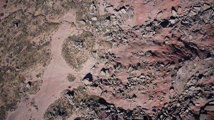
In support of these data needs, the U.S. Geological Survey (USGS) NUSO, at the request of the NPS, flew data collection missions over five archeological sites within the park in October of 2018. Natural color imagery was acquired from the Ricoh GR II mounted on the 3DR Solo and the Sony RX1R II mounted on the FireFLY6 PRO. This high resolution imagery was then processed and used to produce highly accurate, high resolution 3D point clouds, orthomosaics, and digital elevation models for each site. This resulted in the creation of the baseline topographic, erosion, cultural, and archeological data needed to support the preservation and management of these culturally significant sites. In addition, these baseline topographical products can be used in the generation of future landscape change models to help the park prioritize areas for future stabilization to help preserve the significant historical and archeological record of the park.
Study Point of Contact:
Nell Conti, Intermountain Region GIS Coordinator
National Park Service
Paleontological Surveys
Corral Bluffs near Colorado Springs, Colorado
Corral Bluffs is located at the eastern edge of Colorado Springs, Colorado. Its scenic 400-foot-high bluffs contain rich archaeological and paleontological resources as well as providing an important wildlife habitat. The area also preserves numerous paleontological fossils and marks the Cretaceous–Paleogene (K/Pg) boundary, a geologically significant mass extinction event that marks a decline of biodiversity. Many of the exposed outcrops represent the first million years after the extinction of the dinosaurs, an essential and previously unknown part of history. Therefore, the ability to identify and date fossils in this area provided clues to help understand how the planet rebounded from a mass extinction event.
In September 2018, NUSO researchers working with Denver Museum of Nature & Science flew the FireFly6 UAS platform mounted with a Sony RX1RII camera to collect imagery covering the Corral Bluffs study area. The acquired high-resolution imagery created a photogrammetric surface model supporting the extraction of centimeter level elevation data for the hundreds of paleontological fossil locations. Accurate surface elevation data is crucial when back dating fossils using stratigraphy, it places a record in their relationship in the geological time scale. The data was then utilized to paint a “bigger picture” of how mammals recovered and evolved over time.
For more information: https://coloradosprings.dmns.org/
Study Point of Contact:
Dr. Tyler Lyson, Curator of Vertebrate Paleontology
Denver Museum of Nature & Science
Publication:
Fossil Hunting Is Entering a New Technological Age YouTube video
Rapid Response: Volcano Monitoring
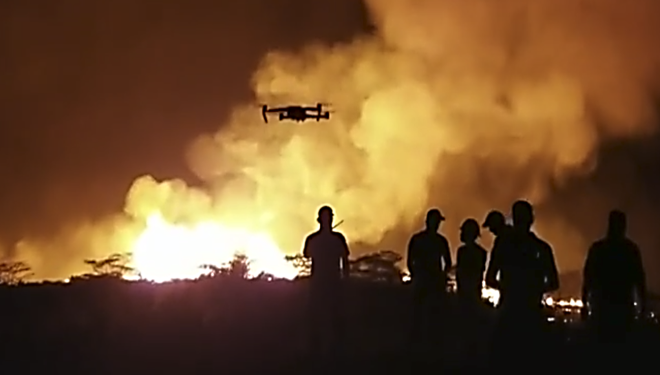
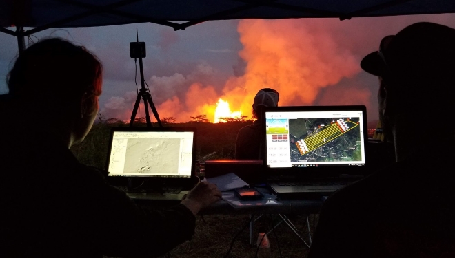
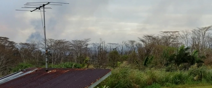
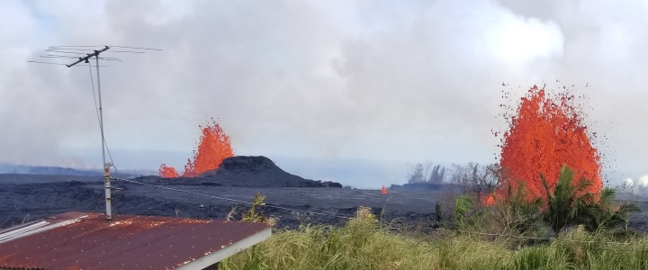
Kilauea Volcano, Hawaii
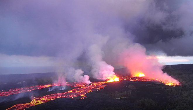
USGS National Unmanned Aircraft Systems (UAS) Project Office and Department of the Interior (DOI) Office of Aviation Services (OAS) equipment and trained personnel were deployed on Thursday, May 17 to support the remote sensing data acquisition needed for the monitoring of the Kilauea Volcano eruptions in Hawaii. Proper authorizations from the Federal Aviation Administration, DOI agencies, and the local Emergency Operations organizations were established and approved for an extended period of UAS operations.
Monitoring of the volcanic activity through use of thermal video imagery and gas sensors on-board the UAS were requested and additional ground mapping of the volcanic fissures around the island are of the highest priorities for geospatial data and will continue to be so into the next few weeks. This near real-time monitoring of the volcano and crater for scientific measurements and modeling should help better predict future activity. In addition, assistance to the local county and fire emergency managers in support of monitoring lava movement toward the Puna Geothermal Venture (PGV) Hawaiian Electric Plant had an immediate demand for geospatial data. UAS payloads have also been adapted/reconfigured as required to provide periodic assistance to local emergency managers, including investigation of lava-surrounded communities for potentially-stranded people and delivery of live video feeds of lava flow conditions/paths to the EOC in support of emergency evacuation efforts.
Hovering Above - UAS' Role in the 2018 Kilauea Volcano Eruption Response, March 6, 2018
UAS team completes mission to map changes within the caldera at Kilauea Volcano's summit, September 11, 2018
Kilauea Volcano's lower East Rift Zone, September 4-7, 2018
Kilauea Volcano's lower East Rift Zone, September 4, 2018
Kilauea Volcano's summit, August 30, 2018
Kilauea Volcano's lower East Rift Zone, August 21, 2018
Kilauea Volcano's lower East Rift Zone, August 17, 2018
Lava erupting from within the 120-foot-high fissure 8 cinder cone built of chilled lava fragments, July 14, 2018
Fissure 8 view from UAS provides critical geologic information, June 29, 2018
Kilauea Summit UAS footage shows an ever growing Halema'uma'u Crater, June 26, 2018
UAS survey of Halema'uma'u crater rim, June 13, 2018
UAS hovering over active lava channel helps in estimating flow velocity, June 6, 2018
UAS mission films details of changes occurring within Halema'uma'u crater at Kilauea's summit, May 31, 2018
USGS UAS mission helps with a successful rescue on May 27, May 27, 2018
UAS mission documents conditions at the Overlook vent, May 30,2018
Lower East Rift Zone UAS flights assist with remote data collection, lava flow mapping, and hazard assessment, May 22, 2018
Aerial imagery of Kilauea summit activity, May 21, 2018
In the News
History of Innovation Leads to Cutting-Edge Technique for Sampling Water Deep Within Kilauea's Volcanic Crater, USGS News Featured Stories, May 1, 2020
Pondering the pond: what Halema'uma'u water chemistry tells us, USGS Hawaiian Volcano Observatory Volcano Watch, November 11, 2019
Drone video gives a clear view inside fissure 8, khon2, August 20, 2018
The United States Geological Survey Is Making America Great (Again And Again), Forbes, July 30, 2018
Look Inside Kilauea Volcano's Collapsing Summit Crater With A USGS Drone, Forbes, June 28, 2018
Using Drones to Monitor Volcano Activity and Save Lives, Commercial UAV News, June 14, 2018
Interior is Using Drones to Save People Trapped by Hot Lava, Nextgov, June 2, 2018
Researchers Use Drone to Save Man's Life from Hawaii's Lava Flow, Interesting Engineering, June 1, 2018
Drone to the rescue: Hawaii resident saved from Kilauea's lava flows, Digital Trends, May 30, 2018
How the USGS Used a Drone to Save Someone from Kilauea’s Lava, Discover Magazine, May 30, 2018
Marshland Restoration Monitoring
Hart Mine Marsh in California
The Hart Mine March, located on the southern end of Cibola National Wildlife Refuge about 20 miles south of Blythe, California, was initially created by historic overbank flood flows from the Colorado River. Over time the dynamic processes that once maintained this marsh have been all but removed. Until recently the marsh had no outlet which has resulted in poor water quality and highly saline areas mostly dominated by invasive saltcedar plants.
In 2011 approximately 255 acres of the Hart Mine Marsh were successfully restored by removing non-native vegetation and excavating and re-contouring the marsh to provide areas for emergent native vegetation and permanent open water. Water management was also improved by adding a series of gated control structures allowing for flexible water control within the conservation area. The restored march now provides suitable habitat for avian and wildlife species including the Yuma clapper rail, California black rail, least bittern, as well as several resident and migrating bird species, and shorebirds along the lower Colorado River.
In support for these march restoration efforts the Lower Colorado River Multi-Species Conservation Program, the U.S. Fish and Wildlife Service, and the U.S. Geological Survey NUSO collaborated on a UAS mission in March of 2018 at the Hart Mine Marsh to collect Photogrammetric and LiDAR datasets that would then be used to reconstruct a “digital marshland” model to measure vegetation response of habitat treatments and to monitor the overall health of the marsh. During this mission the Sony A7r mounted on the Pulse Vapor 55 was used to collect aerial natural color data, and the YellowScan Surveyor mounted on the Pulse Vapor 55 was used to collect LiDAR.
After the successful completion of this mission data analysis and photogrammetric processing methods were used to model the wetland marsh. Digital point clouds were generated using structure from motion techniques applied to the photogrammetic imagery, as well as orthoimagery and digital surface models (DSM). The acquired LiDAR data was also used to generate similar products as well as the final “digital marshland” model.
Study Points of Contact:
Jimmy Knowles, Manager, Adaptive Management Group
Lower Colorado River Multi-Species Conservation Program
David E. Salas, Physical Scientist
Bureau of Reclamation